11th EAEA Envisioning Architecture: Design, Evaluation, Communication Conference in 2013
Track 1 | Visualizing Sustainability - Making the invisible visible
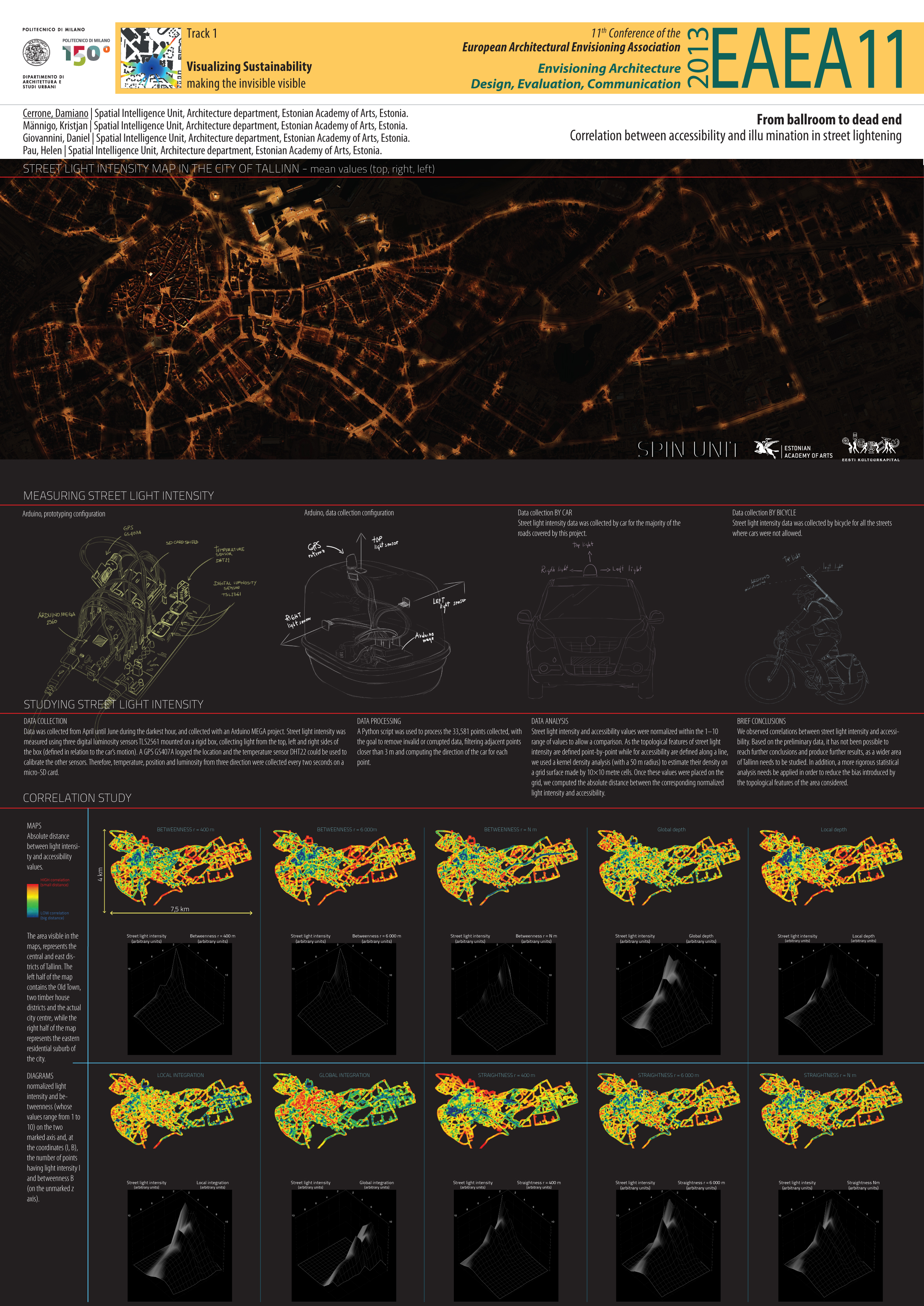
From ballroom to dead end. Correlation between accessibility and illumination in street lightening
Keywords: accessibility; centrality; street light intensity; sustainability; arduino
ABSTRACT
The aim of this ongoing research project is to study the correlation between the intensity of street lights and spatial accessibility. Street light intensity can be measured with different techniques and methods, but generally, in urban environment, is important to study either luminance or the reflectivity. Luminance measures the light intensity per unit area and is relevant to study the emission of light, which may cause flash blindness and glare. Reflectivity measures the amount of light reflected by different surfaces, like the facades of buildings or road surfaces. These measures require specific methodologies and instruments. For the luminance, knowing the angle between the detector and the emitting surface is needed in each measurement. To measure reflectance, measurements for each building or street surface are necessary. As the objective of this research is to measure street light intensity on an urban scale, neither method is convenient for studies on a very large area. Therefore we needed a method to study the whole city in a reasonable time and an instrument what could be mounted on a car or carried by bicycle. Therefore we designed an Arduino-based project to measure the irradiance, i.e. the visible light that reaches the instrument.
To measure accessibility we have used significant measures of Space Syntax and Multiple Centrality Assessment. Depth, Choice and Integration were computed with the use of UCL DepthMap on the manually-drawn axial maps of Tallinn metropolitan region, while Betweenness and Straightness were computed with the use of Urban Network Analyst on the street network of Tallinn administration area. Street light intensity was measured using three digital luminosity sensors TLS2561 mounted on a rigid box, collecting light from the top, left and right sides of the box (defined in relation to the car’s motion). A GPS GS407A logged the location and the temperature sensor DHT22 could be used to calibrate the other sensors. Therefore, temperature, position and luminosity from three direction were collected every two seconds on a micro-SD card. A Python script was used to process the 33,581 points collected, with the goal to remove invalid or corrupted data, filtering adjacent points closer than 3 m and computing the direction of the car for each point.
Street light intensity and accessibility values were normalized within the 1–10 range of values to allow a comparison. As the topological features of street light intensity are defined point-by-point while for accessibility are defined along a line, we used a kernel density analysis (with a 50 m radius) to estimate their density on a grid surface made by 10×10 metre cells. Once these values were placed on the grid, we computed the absolute distance between the corresponding normalized light intensity and accessibility.
We observed correlations between street light intensity and accessibility. Based on the preliminary data, it has not been possible to reach further conclusions and produce further results, as a wider area of Tallinn needs to be studied. In addition, a more rigorous statistical analysis needs be applied in order to reduce the bias introduced by the topological features of the area considered.
AUTHORS
Damiano Cerrone
Spatial Intelligence Unit, Architecture, Estonian Academy of Arts, Tallinn, Estonia
Damiano Cerrone is a spatial planner and analyst with a BA in Urban Planning and GIS achieved at La Sapienza University of Rome and an MSc in Urban Studies at the Estonian Academy of Arts. In the past years he has undertaken an intense research activity funded by EUREGIO for the Development of the Helsinki -Tallinn Transportation and Planning Scenarios, focusing on spatial cohesion, accessibility and the Talsinki Decision Support System. Currently he is Principal Investigator of the Spatial Intelligence Unit ( www.spinunit.eu ) in Tallinn and PhD candidate on the Heritage of urban morphologies.
Kristjan Männigo
Spatial Intelligence Unit, Architecture, Estonian Academy of Arts, Tallinn, Estonia
Daniel Giovannini
Spatial Intelligence Unit, Architecture, Estonian Academy of Arts, Tallinn, Estonia
Helen Pau
Spatial Intelligence Unit, Architecture, Estonian Academy of Arts, Tallinn, Estonia