11th EAEA Envisioning Architecture: Design, Evaluation, Communication Conference in 2013
Track 3 | Conceptual Representation | Exploring the layout of the built environment
Mapping interconnected systems - Visual research into potential manipulations of site
Keywords: site analysis; generative visualization; representational methods
ABSTRACT
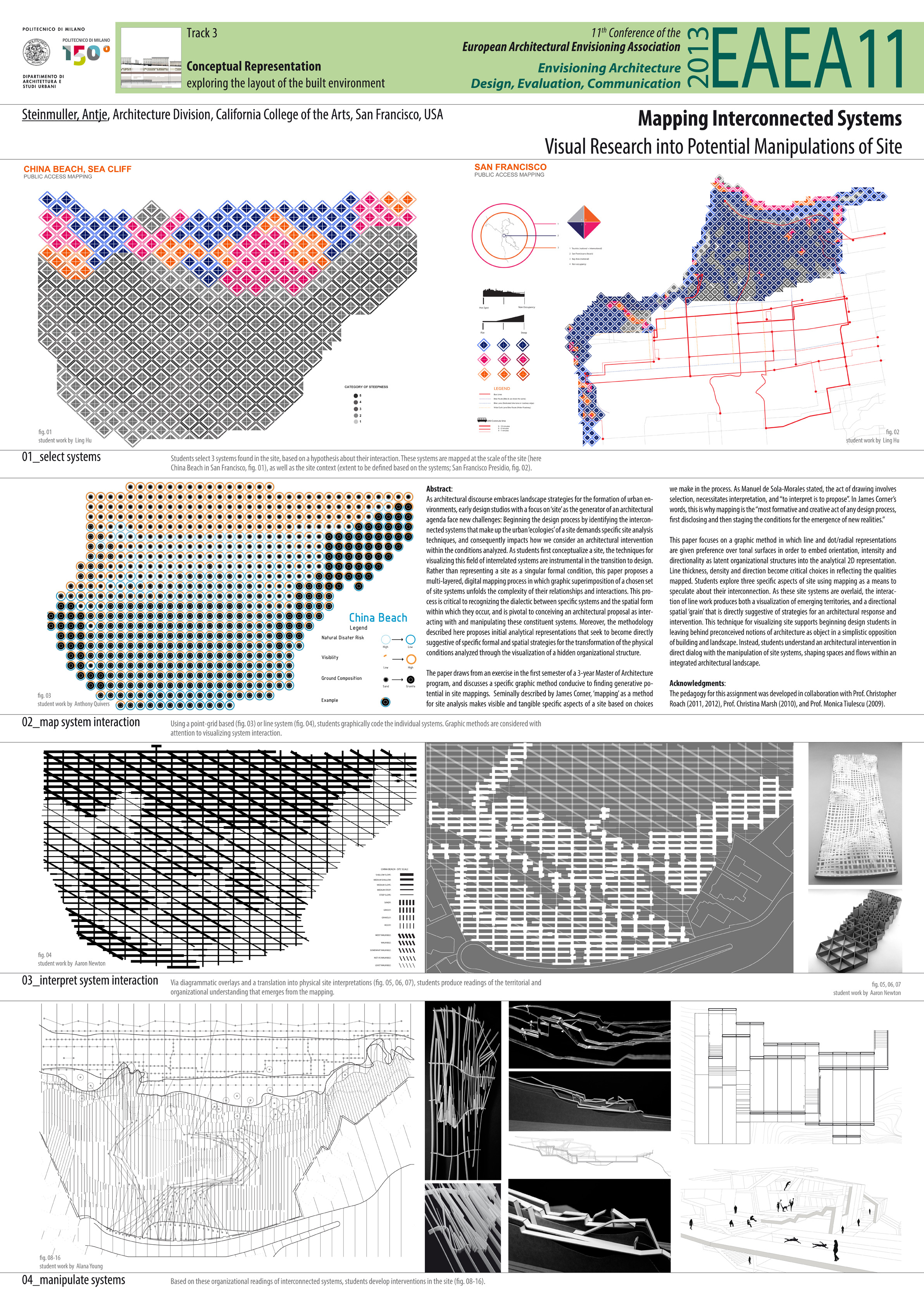
As architectural discourse embraces landscape strategies for the formation of urban environments, early design studios with a focus on ‘site’ as the generator of an architectural agenda face new challenges: Beginning the design process by identifying the interconnected systems that make up the urban ‘ecologies’ of a site demands specific site analysis techniques, and consequently impacts how we consider an architectural intervention within the conditions analyzed. As students first conceptualize a site, the techniques for visualizing this field of interrelated systems are instrumental in the transition to design. Rather than representing a site as a singular formal condition, this paper proposes a multi-layered, digital mapping process in which graphic superimposition of a chosen set of site systems unfolds the complexity of their relationships and interactions. This process is critical to recognizing the dialectic between specific systems and the spatial form within which they occur, and is pivotal to conceiving an architectural proposal as interacting with and manipulating these constituent systems. Moreover, the methodology described here proposes initial analytical representations that seek to become directly suggestive of specific formal and spatial strategies for an architectural transformation through the visualization of a hidden organizational structure in the conditions analyzed.
The paper draws from an exercise in the first semester of a 3-year Master of Architecture program, and discusses a specific graphic method conducive to finding generative potential in site mappings. Seminally described by James Corner, ‘mapping’ as a method for site analysis makes visible and tangible specific aspects of a site based on choices we make in the process. As Manuel de Sola-Morales stated, the act of drawing involves selection, necessitates interpretation, and “to interpret is to propose”. In James Corner’s words, this is why mapping is the “most formative and creative act of any design process, first disclosing and then staging the conditions for the emergence of new realities.” This paper focuses on a graphic method in which line and dot/radial representations are given preference over tonal surfaces in order to embed orientation, intensity and directionality as latent organizational structures into the analytical 2D representation. Line thickness, density and direction become critical choices in reflecting the qualities mapped. Students explore three specific aspects of site using mapping as a means to speculate about their interconnection. As the three site systems are overlaid in the mapping, the interaction of line work produces both a visualization of emerging territories, and a directional spatial ‘grain’ that can become directly suggestive of strategies for an architectural response and intervention. This technique for visualizing site supports beginning design students in leaving behind preconceived notions of architecture as object in a simplistic opposition of building and landscape. Instead, students understand an architectural intervention in direct dialog with the manipulation of site systems, shaping spaces and flows within an integrated architectural landscape.
AUTHOR
Antje Steinmuller
Department of Architecture, California College of the Arts, San Francisco, USA