Experiencing Enota Park
You are invited to explore the proposed design of Enota Park, which was designed by Atlanta BeltLine, Inc. The design transforms the small Enota Park play-lot into an 8-acre greenspace that will include active, passive, and woodland recreational areas adjacent to the Westside Trail of the Atlanta Beltline Trail loop.
This survey is administered by the university Politecnico di Milano as part of a collaborative urban planning research project* and is not affiliated or endorsed by Atlanta BeltLine, Inc. On the next page you will be able to explore the area as 360° panoramic scenes, which will be followed by a questionnaire. By sharing your opinions about the site, you will contribute to the advancement of the overall research project.
We thank you for your cooperation!
We thank you for your cooperation!
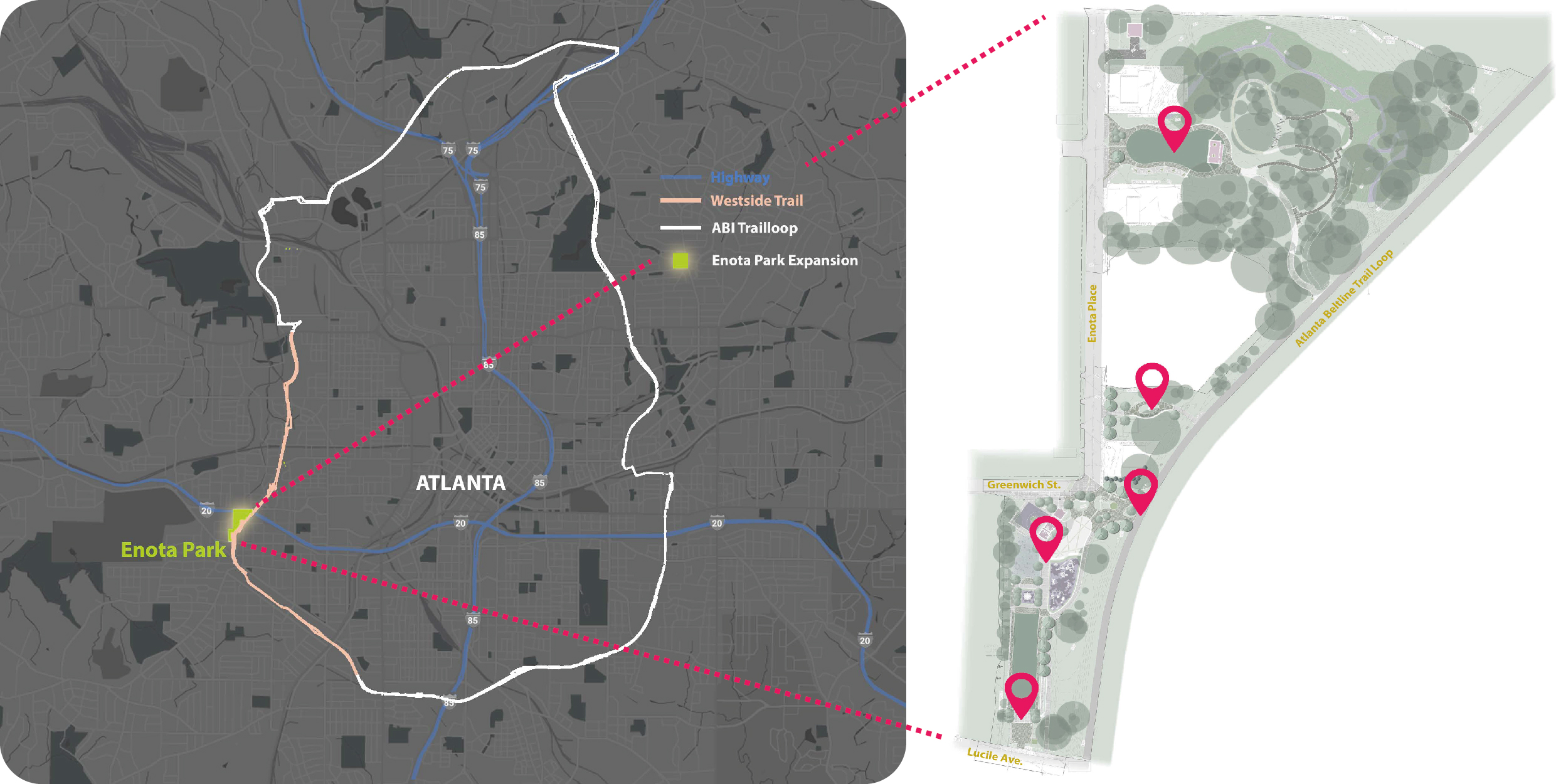
Left: Map of Atlanta Beltline Trail loop (white), with Enota Park labeled (green) and the Westside Trail (peach);
Right: Map of Enota Park Expansion marking the 5 locations that correspond to the 360 panoramic scenes
Instructions
We ask you to answer some general information about yourself before starting the experience. When finished, there are a total of five scenes to explore. For each scene follow the steps below:Step 1 Pan around the image to explore the scene by using your mouse (if using a computer) or finger (if using a touch-screen device). Form Mac and PC you can also pan around the image by clicking the 4 arrows to navigate up, down, left, and right
Step 2 When a point of view draws your attention press the ICON
Step 3 Click
Step 4 Repeat steps for the remaining scenes.
The total time to complete the questionnaire is around 15 minutes.
Information on the protection of personal data
By checking the box below, I declare that I have read and fully accept the conditions relating to the “privacy notice and declaration of consent to the treatment of personal data” viewable and downloadable at the following link: privacy policies.
By checking the box below, I declare that I have read and fully accept the conditions relating to the “privacy notice and declaration of consent to the treatment of personal data” viewable and downloadable at the following link: privacy policies.

*This project has received funding from the European Union’s Horizon 2020 research and innovation program EIT Digital 2019 and 2020 “AR4CUP: Augmented Reality for Collaborative Urban Planning”. The sole responsibility of this publication lies with the author. The European Union is not responsible for any use that may be made of the information contained therein.
exp-EIA© - experiential Environmental Impact Assessment
(Copyright BOIP N. 123453 - 06.05.2020 & Copyright BOIP N. 130516 - 25.02.2021)
Patent for Invention application N. 102021000017168 - 30/06/2021
Patent for Invention application N. 102021000017168 - 30/06/2021
For more information about the survey, please contact:
marco.boffi@unimi.it (University of Milan) - Department of Cultural Heritage and Environment, barbara.piga@polimi.it (Politecnico di Milano- Dept. of Architecture and Urban Studies - Laboratorio di Simulazione Urbana Fausto Curti)


marco.boffi@unimi.it (University of Milan) - Department of Cultural Heritage and Environment, barbara.piga@polimi.it (Politecnico di Milano- Dept. of Architecture and Urban Studies - Laboratorio di Simulazione Urbana Fausto Curti)