11th EAEA Envisioning Architecture: Design, Evaluation, Communication Conference in 2013
Track 3 | Conceptual Representation | Exploring the layout of the built environment
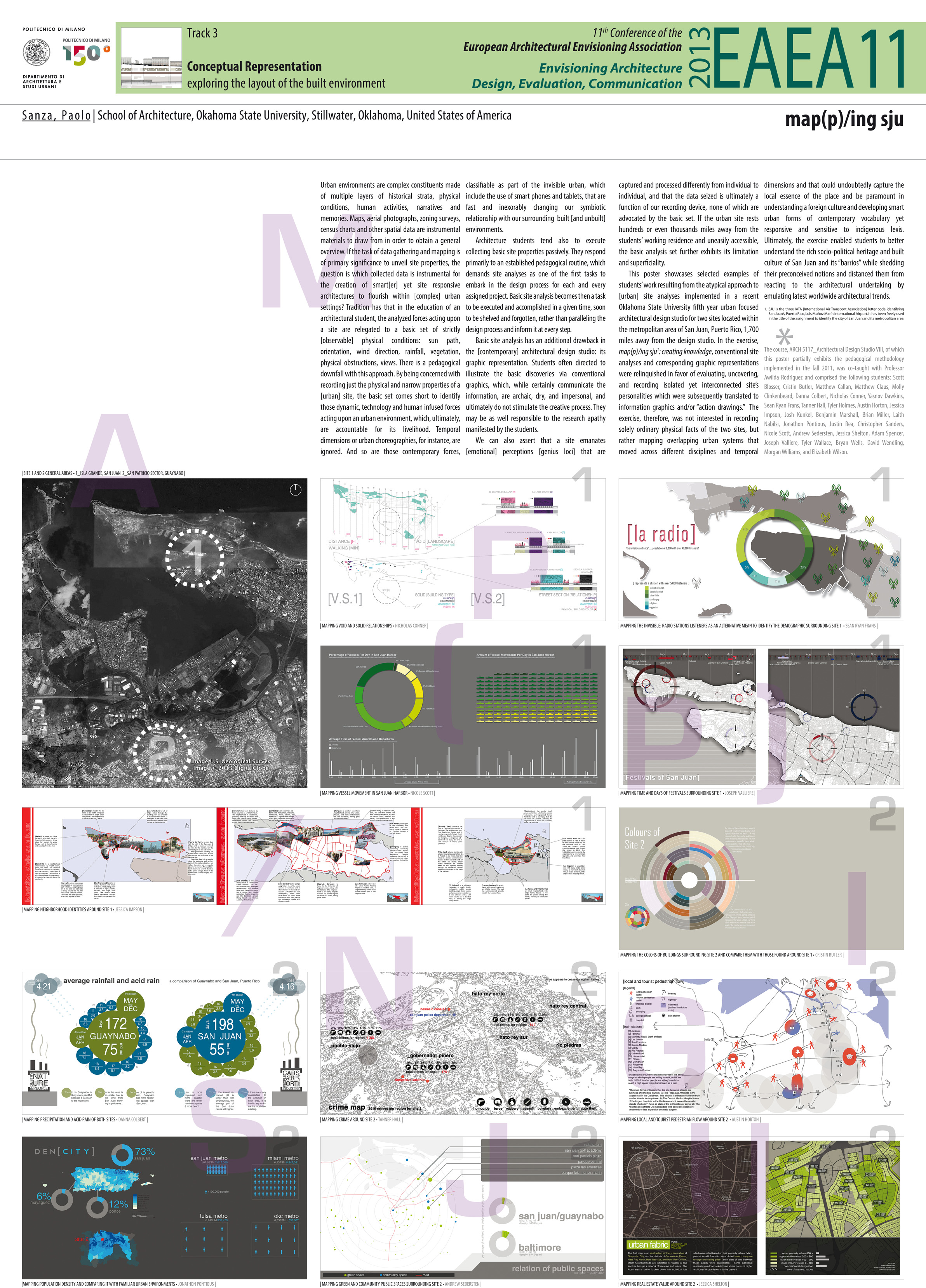
Map(p)/ing sju
ABSTRACT
Urban environments are complex constituents made of multiple layers of historical strata, physical conditions, human activities, narratives and memories. Maps, aerial photographs, zoning surveys, census charts and other spatial data are instrumental materials to draw from in order to obtain a general overview. If the task of data gathering and mapping is of primary significance to unveil site properties, the question is which collected data is instrumental for the creation of smart[er] yet site responsive architectures to flourish within [complex] urban settings? Tradition has that in the education of an architectural student, the analyzed forces acting upon a site are relegated to a basic set of strictly [observable] physical conditions: sun path, orientation, wind direction, rainfall, vegetation, physical obstructions, views. There is a pedagogical downfall with this approach. By being concerned with recording just the physical and narrow properties of a [urban] site, the basic set comes short to identify those dynamic and human infused forces acting upon an urban environment, which, ultimately, are accountable for its livelihood. Temporal dimensions or urban choreographies, for instance, are ignored. And so are those contemporary forces, classifiable as part of the invisible urban, which include the use of smart phones and tablets, that are fast and inexorably changing our symbiotic relationship with our surrounding built [and unbuilt] environments. Basic site analysis has often an additional drawback: its graphic representation. Students are customarily directed to illustrate the basic discoveries via conventional graphics, which, while certainly communicate the information, are archaic, dry, impersonal, and do not stimulate the creative process. If the urban site rests hundreds or even thousands of miles away from the students’ working residence and uneasily accessible, the basic analysis set further exhibits its limitation and superficiality.
In a recent Oklahoma State University fifth year urban focused architectural design studio, conventional site analyses and corresponding graphic representations were relinquished in favor of evaluating, uncovering, and recording isolated yet interconnected site’s personalities which were subsequently translated to information graphics and/or “action drawings.” The exercise was not interested in recording [solely] ordinary physical facts of two diverse sites within the metropolitan area of San Juan, Puerto Rico, 1,700 miles away from the design studio, but rather mapping overlapping urban systems that moved across different disciplines and temporal dimensions and that could undoubtedly capture the local essence of the place and be paramount in understanding a foreign culture and developing smart urban forms of contemporary vocabulary yet responsive and sensitive to indigenous architectural lexis. Ultimately, the exercise enabled students to better understand the rich sociopolitical heritage and built culture of San Juan, its metropolitan area, and its “barrios” while shedding their preconceived notions and distanced them from reacting to the architectural undertaking by emulating latest worldwide architectural trends.
AUTHOR
Paolo Sanza
School of Architecture, Oklahoma State University, Stillwater, Oklahoma, United States of America